The rugged and mountainous terrain in Bhutan is ideal for both on-road and off-road mountain biking. This activity is gaining popularity among visitors and locals alike. Biking routes come in a range of options, from smooth rides on paved roads to challenging off-road trails that traverse rough terrain. This sport provides a special closeness to the environment rarely experienced when in vehicles. As improved roads replace old ones and the number of off-road paths grows, biking in Bhutan emerges as an exceptional approach to experiencing and engaging with the country, its people and environment.
Biking in Bhutan includes paved roads, dirt roads and mountain trails. Traffic is minimal, offering an intimate experience. For the adventurous, side trips to “off-road” paths are available. Trails suit various bike types like MTB, Hybrid, and Road, depending on your biking style and skill. Routes typically pass through rural towns and villages, offering a serene encounter with agrarian and natural landscapes alongside your tour group.
Optional hikes with climbing are available. Certain climbs are demanding, one lasting over seven hours. You pedal uphill to a height of two miles (3400 meters) above sea level. Your effort is rewarded with a stunning view and memorable experience. Riders need good fitness, stamina and mountain biking expertise. Tours are full van support for resting if needed. Trails pass through villages and temples, offering informative breaks.
Day 1 (Monday, 7 April 2025): Delhi – Paro (Flight KB 203: 04:10/06:40)
Upon arrival at Paro International airport, you will be met by your guide. In the afternoon, you will have an opportunity to explore the beautiful town of Paro and pick up your mountain bikes.
Day 2 (Tuesday, 8 April 2025): PARO – TIGER’S NEST TEMPLE
After breakfast, drive to the base of the famous Taktsang Monastery or Tiger’s Nest, which clings to a sheer rock face at a height of 2600m above sea level. The climb is quite steep but ponies are available for those who feel they cannot make the climb themselves.
The primary Lhakhang or main temple was built around Guru Rimpoche’s meditation cave in 1684 by the Penlop of Paro, Gyalse Tenzin Rabgay. This incredible monastery clings to the edge of a sheer rock cliff that plunges 900m into the valley below. Legend has it that Guru Padmasambhava, the tantric mystic who brought Buddhism to Bhutan in 747 AD, flew here on the back of a flying tiger, Dorje Drolo from Kurtoe Singye Dzong in the east.
Later in the evening visit the farm house and explore the Beautiful town of Paro for shopping and etc.
Dinner and overnight at your hotel in Paro.
Day 3 (Wednesday, 9 April 2025): Paro – Haa
Embark on a leisurely journey from your hotel, meandering through the picturesque Paro valley. As you traverse farmland and scattered hamlets, the path gradually inclines towards the Chelela. Beginning the ascent, you will steadily gain elevation, treated to the glimpses of the majestic snow-capped peaks of the Bhutan Himalaya to the north dominated by Mount Jhomolhari and Jichu Drake at the western end of the country.
Covering approximately 36 kilometers, this ascent might span up to 5 hours, culminating at the prayer-flagged summit of the pass, standing at an altitude of around 3822m. Given the abrupt transition to such heights, individuals feeling the strain can opt for a ride on the support vehicle at any time.
At the pass, there will be a snack lunch and ample refreshments before the breath taking 20 kilometers descent. After an initial cruise between the trees, you head down into the valley by way of a series of 10 hairpin turns.
Dinner and overnight at your hotel in Haa.
Day 4 (Thursday, 10 April 2025): Haa – Thimphu
Today’s destination is the Bhutanese capital of Thimphu, 110 kilometers from Haa. Thankfully, the journey unfolds on smooth, mostly level roads with minimal traffic. Begin with a relaxed pace, covering the initial 40 kilometers effortlessly, before tracing the gentle descent alongside the Haa River, heading southeast and then northward to reach the junction with Bhutan’s main East-West highway at Chuzom (2068m).
Then follow the serene flow of the Thimchu River upstream, winding through a blend of rice fields and coniferous forests. Pause at a suitable spot along the route for a delightful lunch break, then continue through a narrow gorge and witness the valley gradually widening at Namseling. Finally, the suburbs of Thimphu begin to appear, with the striking Simtokha Dzong in the middle of the valley.
As Bhutan’s primary urban center, Thimphu stretches across the wide valley with a unique charm. Watching the local people, adorned in their traditional attire, going about their activities in the typically unhurried Bhutanese manner, is a fascinating experience, especially amidst the bustling gatherings in the town square.
Dinner and overnight at your hotel in Thimphu.
Day 5 (Friday, 11 April 2025): Thimphu – Punakha
Today’s journey takes you from Thimphu to Dochula, reaching at an altitude of 3050m over a 22 kilometers ride with a height gain of 670m. En route, the hillsides adorned with lush temperate forests, with an abundance of rhododendrons and magnolias, captivate the senses. The lower slopes are even more vibrant with orange trees, bananas, and bamboo, serving as habitat for various species of deer and monkeys.
At the pass, marked by many prayer flags and chortens, a support vehicle awaits, providing a moment for rest and refreshment amidst the breathtaking panorama of the Eastern Himalaya, featuring towering 7000m peaks of Lunana in northeastern Bhutan.
Descending from Dochula into the Punakha valley is an awe-inspiring experience, spanning 1700m of descent through lush forests and dense jungle, covering a distance of 50 km.
Upon arriving at your hotel, a quick shower and change prepare you for a side trip to Punakha, Bhutan’s former capital. Nestled at the confluence of the Mo (Mother) Chu and the Pho (Father) Chu rivers, Punakha Dzong serves as the winter home for over 1000 monks. The annual Punakha tshechu festival commemorates the historic victory over the Tibetans, who were thwarted in their attempt to reclaim the sacred statue of Avalokiteshvara, brought to Bhutan by Shabdrung. A guided tour of the magnificent dzong, built in 1637 and extensively restored following a flood, more than a decade ago, offers insight into Bhutan’s rich cultural heritage.
Dinner and overnight at your hotel in Punakha.
Day 6 (Saturday, 12 April 2025): Punakha – Gangtey
The completion of the Central Road across the Black Mountains in recent years has brought about significant transformations for the people of central Bhutan. Departing from our hotel, we bike downhill to the river, reaching one of the lowest points of our journey at 600m above sea level. Following a brief ascent to the village of Wangdue, we encounter a relatively flat road for 20 kilometers, leading to a bridge spanning the river just beyond the village of Tikke. Here, a tea break offers respite before embarking on a lengthy ascent over the Black Mountains. This climb, though appearing deceptively long, entails a gain of nearly 2000m, culminating at a junction with the side road to Gangtey, located a few kilometers beyond Nobding.
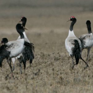
Crossing the pass, we descend into the Phobjikha valley, renowned as one of the few winter homes of the black-necked crane, which migrates here from the Central Asiatic Plateau in November. A brief descent brings us into the valley and to our hotel, situated a few kilometers beyond the small village of Gangtey at an elevation of 3000m.
Dinner and overnight at your hotel in Gangtey.
Day 7 (Sunday, 13 April 2025): Gangtey – Trongsa
If the black-necked cranes are around, you will likely hear their distinctive calls from your hotel, located near their feeding grounds. These birds are known for their tolerance of human presence and can often be found feeding near human settlements and alongside domestic livestock, possibly due to reverence they receive in local religious beliefs across much of their habitat.
Continuing your journey eastward, you will traverse over the Pelela at 3300m, with a good chance of encountering langur monkeys in the forest along the way. As the forest thins out at the pass, the towering peak of Jomolhari at 7219m may be visible. The Pelela holds significance as the traditional boundary between Western and Eastern Bhutan, with the landscape beyond the pass distinctively different from the western side.
A thrilling descent of 1530m follows, with nearly continuous downhill riding for an additional 60 kilometers to Trongsa. A stop for lunch at Chendebji offers the chance to admire the magnificent stupa, built to ward off the demons of the valley. After crossing a bridge at Nikachu, you will enter the Trongsa district, where the road carves through dramatic cliffs high above the Mangdechu River. The scenery is breathtaking, with dense forests stretching as far as the eye can see, and Trongsa Dzong commanding attention from 30 kilometers away, nestled at the end of the valley. Trongsa means “new village”. It was founded in the 16th century, which is relatively recent for Bhutan’s history. Hopefully, there will be time in the afternoon to explore the amazing dzong which, perched on a spur overlooking the Mangdechu River, offering commanding views in every direction. Trongsa sits at an altitude of about 2200m.
Dinner and overnight at your hotel in Trongsa.
Day 8 (Monday, 14 April 2025): Trongsa – Bumthang
The ascent out of Trongsa is swift, navigating through a series of hairpin blends that offer splendid views back to the dzong and across the valley. After passing through cultivated fields for a while, the route re-enters the forest, eventually leading to the Yotongla at 3400m, approximately 30 kilometers from Trongsa.
Descending to the village of Chumey at a lower elevation of 2650m, the landscape undergoes a striking transformation as we enter the broad Bumthang valley. After a brief ascent to Kikila, a breathtaking descent unfolds, revealing the charming valley of Bumthang with Jakar Dzong prominently perched high above, visible from nearly 20 kilometers away. The altitude at Bumthang is about 2600m.
Dinner and overnight at your hotel in Bumthang.
Day 9 (Tuesday, 15 April 2025): Bumthang – Ura
Today’s ride entails an ascent of 900m to your fifth pass, the Shertangla, after nearly 40 kilometers of ride. Nestled within the highest of the Bumthang valleys, the Ura Valley boasts vast sheep pastures, offering a picturesque panorama of the mountains of Lunana to the north just before reaching the pass. Descending from the pass, you will traverse through long loops amidst lush meadows and cultivated fields, eventually arriving at the charming Ura village. The altitude here is about 3000m.
Dinner and overnight camping in Ura.
Day 10 (Wednesday, 16 April 2025): Ura – Mongar
Bhutan’s highest road pass! Today is a long day, requiring an early start. After a brief descent to a bridge, you will immediately commence the climb towards the Thrumshingla pass at 3800m. The gradual ascent over 30 kilometers unveils breathtaking scenery, as you wind through dense forests of conifers and rhododendrons. Divided into two segments, the climb includes a minor pass en route to the Thrumshingla, followed by a short descent to a bridge across a river, marking the conclusion of the high-altitude climbs.
Lunch will be served at the pass, preceding what can only be described as one of the most exhilarating and visually stunning descents in the biking world. From the Thrumshingla, the road plunges 3200m to the valley floor at 600m, spanning an impressive 85 kilometers. The descent unfolds amidst dark coniferous forests, transitioning into a blend of deciduous and coniferous woodlands before entering the semi-tropical zone at around 1800m. Bamboo and a rich array of rare plant life adorn either side of the road. Notorious for its hair-raising nature, the 20 kilometers stretch between Sengor and Namling is renowned as the most thrilling section of Bhutan’s roads, perfect for mountain bikes. Carved into the Cliffside with a steep drop for most of the way, this segment promises an exhilarating experience. By the time you reach Lingmithang, expect a considerable rise in temperature. After five hours and 85 kilometers of exhilarating downhill adventure, most will find themselves rendered speechless. However, the journey doesn’t end there, a final 20 kilometers climb to Mongar, situated at an altitude of 1600m, provides a fitting finale to this epic day of biking.
Dinner and overnight at your hotel in Mongar.
Day 11 (Thursday, 17 April 2025): Mongar – Trashigang
Prepare for another exhilarating descent today, but first, you have another 20 kilometers of climbing ahead as you make your way towards the Korila at an altitude of 2400m, the first of two relatively minor passes. Following this ascent, the road swiftly descends through picturesque cornfields and banana groves. After 10 kilometers, you will encounter the beginning of the renowned hairpin turns at Yadi (1500m), a thrilling stretch of 30 kilometers marked by a seemingly endless series of bends, eventually leading to a bridge across the Sherichu at 600m. This descent marks the second longest of the trip, boasting a dazzling drop of 1850m! Now immersed in a hot tropical climate, you will enjoy delightful ride along the side of the Gamrichu River towards the bridge and check post below Trashigang. The day culminates with a challenging 10 kilometers climb, wrapping up what has been quite a demanding day of biking. Trashigang, a desitation that sees very few tourists, offers limited facilities, but rest assured, you will be accommodated in the finest lodging available in the town. Situated at an altitude of about 1100m, Trashigang awaits, promising a unique and authentic experience.
Dinner and overnight at a guesthouse in Trashigang.
Day 12 (Friday, 18 April 2025): Trashigang – Sagteng (Semi-Nomadic Valley)
After breakfast at your hotel, embark on an adventurous and scenic journey to Sakteng, passing through Rangjung. Sakteng is a semi-nomadic community nestled in the remotest and easternmost part of Bhutan. It shares borders with Phongmey and Merak blocks of Trashigang district, as well as the Arunachal Pradesh state of India. The majority of the Sakteng community is situated within the Sakteng Wildlife Sanctuary, the world’s only reserve dedicated to protecting the habitat of the yeti, or abominable snowman. This mountainous and rugged sanctuary is also famous for being the natural habitat of the rare Blue Poppy, Bhutan’s national flower.
The Merak-Sakteng valleys, a semi-nomadic region, were officially opened for tourism in 2009, and since then, only a few foreign visitors have explored this remote highland area. Despite its remote and isolated location, Merak-Sagteng valleys boasts pristine natural beauty and a distinct cultural heritage. The area is home to a diverse array of bird species, including the rufous-necked hornbill (Aceros nipalensis), Chestnut-breasted Partridge (Arborophila mandellii), and Palla’s Fish eagle (Haliaeetus leucoruphus) in addition to a diverse range of rhododendron flower species, found in abundance.
The people of Sakteng rely heavily on livestock products such as butter, cheese, yak meat, wool, and zoetay or yidpa, a unique Bhutanese delicacy made from fermented cheese for their livelihoods.
Dinner and overnight at your homestay in Sakteng Valley.
Day 13 (Saturday, 19 April 2025): Sakteng – Trashigang
After breakfast, embark on an enchanting journey, passing through the picturesque villages of Phongmey, Merak and Radhi. Today, you will relish a scenic biking adventure through the picturesque landscapes of Radhi and Phongmey, popularly known as the “rice bowl of the east” in upper Trashigang.
En route, we will witness some raw silk weaving in the village of Radhi. You will also get an opportunity to visit the Rangjung Woeselchholing Monastery. Established in 1989 by His Eminence Dungsey Garab Dorje Rinpoche (Younger brother of Khyentse Rinpoche), the monastery aims to foster the study of Buddha dharma in the Dudjom New Treasure Lineage and conduct dharma activities for the Buddhist community.
Later in in the afternoon, explore the small city of Trashigang and Dzong overlooking the Gamri-chhu River.
Dinner and overnight at your hotel in Trashigang.
Day 14 (Sunday, 20 April 2025): Trashigang – Samdrup Jongkhar
By now you will have reached the most easterly point of your journey as the road now heads south for 180 km to Samdrup Jongkhar – Bhutan’s eastern road border with Assam. This day is another tough one and often catches people out! At first there will a hot climb for 30 km to the university at Kanglung, then a further 10 km to a small pass at 2450m, with views of the peaks of north-eastern Bhutan and Arunachal Pradesh.
You will climb to another minor pass at 2450m before descending to Wamrong at 2000m, a sub-district under Trashigang. Unlike western Bhutan, where the road goes over passes between one valley and the next, the road here follows ridges almost the whole way and is marked throughout with stone chortens. A long climb with the road switching from left to right across the spine of the ridge, leads to a high point at 2450m and then down through two small settlements. The road descends rapidly to the plain through dense tropical forest with an abundance of teak and bamboo.
In Dewathang there is a large memorial chorten dedicated to those who have lost their lives building the road across Bhutan. A few km beyond the village lies a police check-post and a few km beyond that is the town of Samdrup Jongkhar. Afterwards, you will ride to the border gate for photographs and then return to your hotel in town. Here a small celebration will certainly be in order as you will be one of only a handful of people who have completed what is arguably the most beautiful and challenging bike ride in the world.
Dinner and overnight at your hotel in Samdrup Jongkhar.
Day 15 (Monday, 21 April 2025): Samdrup Jongkhar – Guwahati – Delhi
After breakfast, our Indian based representatives will take you on the three hour drive through to Guwahati International Airport in time to meet most early afternoon domestic and international connections.
Reviews
There are no reviews yet.